Water Management Data System Menu
Wallisville Project Dashboard
The hydrologic conditions and the hydrologic data provided are for informational purposes only. The Corps of Engineers does not warrant the correctness or the accuracy of the hydrologic data or the hydrologic conditions presented herein. Official data can be obtained by writing to the Water Management Section, Galveston District Corps of Engineers, 2000 Fort Point Road,Galveston,TX 77550
Trinity River Gages - Wallisville Project
The gages below are monitored by the Water management team on a daily basis for salt water intrusion project operations at the Wallisville Lake project on the Trinity River. The data obtained is analyzed in conjunction with weather information to make informed decisions regarding wallisville project operations.
Specific Conductance, Stream Flow and Water Velocity
|
Specific Conductance - Downstream of Barrier |
Specific Conductance - Upstream of Barrier |
Specific Conductance - Old River at Buckeye Island
near Anahuac |
|
Stream Elevation - Downstream of Barrier |
Stream Elevation - Upstream of Barrier |
Specific Conductance - Old River Cutoff near Moss
Bluff (Structure A) |
|
Stream Elevation - Upstream from PT-Old River Cutoff
near Moss Bluff (Structure A) |
Stream Elevation - Downstream from Vel Meter-Old River
Cutoff near Moss Bluff (Structure A) |
Stream Water Velocity - Old River Cutoff near Moss
Bluff (Structure A) |
|
Streamflow - Trinity River near Goodrich |
Streamflow - Trinity River at Liberty |
Streamflow - Trinity Rv at IH 10 near Wallisville, TX |
Streamflow - Trinity River near Goodrich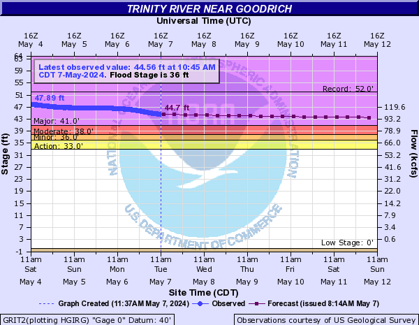
|
Stream Elevation - Trinity River at Liberty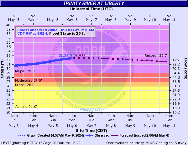
|
Stream Elevation - Trinity River near Moss Bluff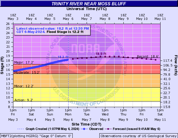
|
Pool ELevation - Lake Livingstone
|
