Water Management Data System Menu
San Bernard River Dashboard
The hydrologic conditions and the hydrologic data provided are for informational purposes only. The Corps of Engineers does not warrant the correctness or the accuracy of the hydrologic data or the hydrologic conditions presented herein. Official data can be obtained by writing to the Water Management Section, Galveston District Corps of Engineers, 2000 Fort Point Road,Galveston,TX 77550
San Bernard River Stream Flow and Stream Water Elevation
|
Streamflow - San Bernard River near Sweeney |
Stage - San Bernard River near East Bernard 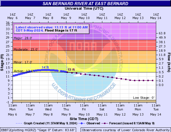
|
|
Streamflow - San Bernard River near Boling |
Stage - San Bernard River near Boling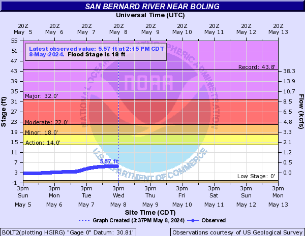
|
Stage - San Bernard River near Old Ocean 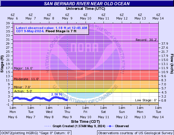
|
San Bernard River
The San Bernard River begins near New Ulm in Southwest Austin County and flows southwesterly for 105 miles into western Brazoria County where it flows into Cedar Lake and ultimately the Gulf of Mexico. North of SH 35 the banks are lined with bottomland hardwood forest and cypress swamps, while south of SH 35 they are lined with interspersed pastureland and houses. The river provides habitat for a diverse fish community comprised of gars, minnows, river carpsuckers, smallmouth buffalos, channel catfish, and several sunfish species among others. The ecologically significant segment is from the confluence with the Intracoastal Waterway (GIWW) in Brazoria County upstream to the Austin/Fort Bend County line
Flooding events within the San Bernard River area is primarily from high river flows after heavy rains upstream or hurricanes and tropical storms from the Gulf Coast that cause severe flooding. During flood and high river flow events, a hazard exists for all traffic through the GIWW, necessitating the need to provide increased traffic management. That management is currently via the Colorado River Locks and the Brazos River Flood Gates. When the mouth of San Bernard at mouth was impeded in 2005 this caused it to causing it to drain into the GIWW. When gate head differential is greater than 1.8 ft at the Brazos River Flood Gates, this can cause an issue at the west gate due to the San Bernard River flowing through the west gate.
USACE Water Management provides information/data support for implementation and execution of navigation restrictions for the locks on the GIWW, Galveston District at the Brazos River crossings. This helps achieve USACE navigation mission of providing safe, reliable, efficient, effective, and environmentally sustainable waterborne transportation systems for movement of commerce, national security needs, and recreation
Water Management Support
• When high rain/storm events and or flooding is
forecast, the water management team monitors the Stage
of water at the following gages on the San Bernard
River: San Bernard River at East Bernard, Boling and Old
Ocean.
• The water management regulator on duty, then
communicates the information on when and where the river
will likely go above flood stage to the Lockmaster
charged with the immediate control and management of the
lock and of the area set aside as the lock area.

