Water Management Data System Menu
Colorado River Dashboard
The hydrologic conditions and the hydrologic data provided are for informational purposes only. The Corps of Engineers does not warrant the correctness or the accuracy of the hydrologic data or the hydrologic conditions presented herein. Official data can be obtained by writing to the Water Management Section, Galveston District Corps of Engineers, 2000 Fort Point Road,Galveston,TX 77550
Colorado River Stream Flow and Stream Water Elevation
|
Streamflow - Colorado River near Columbus
|
Stage - Colorado River near Columbus
|
|
Streamflow - Colorado River near Wharton |
Stage - Colorado River near Wharton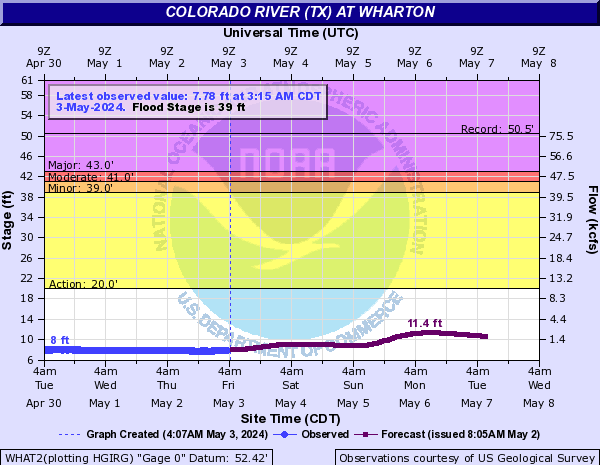
|
|
Streamflow - Colorado River near Bay City |
Stage - Colorado River near Bay City
|
|
Streamflow - Colorado River near Wadsworth |
Stage - Colorado River near Wadsworth |
|
Stage - Colorado River Bypass Channel near
Matagorda,TX: EAST LOCK |
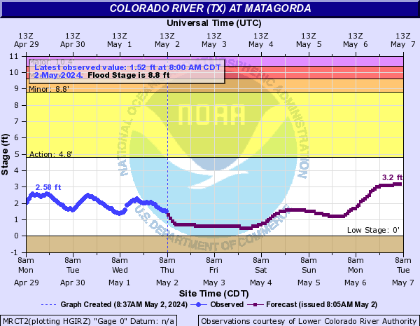
Stage - Colorado River near Matagorda
|
|
Stage - Colorado River Bypass Channel near
Matagorda,TX: EAST RIVER
|
Stage - Colorado River near Matagorda
|
|
Stage - Colorado River Bypass Channel near
Matagorda,TX: WEST LOCK |
Stage - Colorado River near Matagorda
|
|
Stage - Colorado River Bypass Channel near
Matagorda,TX: WEST RIVER |
Stage - Colorado River near Matagorda
|
Important Links
| Colorado Links |
USGS Colorado River near Bay City, TX |
USGS Colorado River near Matagorda,TX |
Colorado River Locks
The Colorado River is an approximately 862-mile-long river that has both its source and mouth in Texas. It originates south of Lubbock, on the Llano Estacado near Lamesa. It flows generally southeast out of the Llano Estacado and through the Texas Hill Country, then through several reservoirs and continues flowing southeast and then finally flowing into West Matagorda Bay, crossing the Gulf Intracoastal Water Way (GIWW) near Matagorda, Texas. The Colorado River plays an important role to the state of Texas economy, its environment, industry, and agriculture. The Colorado River Locks alone enables the transit of more than 12,000 tows, over 30,000 recreational or commercial vessels and 20 million tons of product annually,providing an essential service that significantly impacts local communities, the state, and our nation's economies.
The Colorado River Locks Area (CLR) is situated at the Lower end of the Colorado River on the Texas Gulf Coast. The Colorado River Lock area also contains portions of three sub-watersheds: (1) the Central Matagorda Bay watershed (HUC 12100401) in the western half, (2) the Lower Colorado River watershed (HUC 12090302) in the eastern half, and (3) the East Matagorda Bay watershed (HUC 12090402) in the extreme eastern end. The CRL System in conjunction with the Brazos River Flood gates (BRFG) constitute the western portion of the GIWW, both of which provide shallow-draft navigation between deep-draft ports along the Texas coast and connects these ports to the inland navigation system comprised of the Mississippi River and its tributaries.
The Colorado River Locks provide navigation access through the GIWW, assisting vessels crossing the intersection of the Colorado River. The lock chamber is essentially a stationary box constructed in the GIWW with two matching gates at each end that close. The Colorado River Lock chambers are 1,200 feet long and 75 feet wide, with a lock situated on both the east and west sides of the Colorado River Crossing of the GIWW. The gates open or close to allow the water levels to correspond with either the GIWW or the Colorado River levels. One set opens to let the watercraft enter and then closes to allow the water level in the chamber to be raised or lowered depending on the direction of travel.The other set of gates then opens to let the boat leave. The lock chamber never empties completely but drops only as far as the pool level of the Colorado River or GIWW on either side of the lock. The images below show the location of the Colorado River as well as the East and West locks on the Colorado River near Matargorda.
Flooding events within the Colorado River Lock area are primarily due to high river flows after heavy rains upstream or hurricanes and tropical storms from the Gulf cause severe flooding. During flood and high river flow events, a hazard exists for all traffic necessitating the need to provide increased traffic management. In the past, the industry had self-imposed restrictions by individual companies, on how and when they transit during high flows, but that role is now performed by the Lockmaster. When the discharges are between 10000-20,000 cfs and river velocities exceed 2.0 mph navigation restrictions are imposed by the Lockmaster according to the procedures presented in the “Guidelines for Traffic restriction and Operation of Locks” section below.
USACE Water Management provides information/data support for implementation and execution of navigation restrictions for the locks on the GIWW, Galveston District at the Colorado River crossings. This helps achieve USACE navigation mission of providing safe, reliable, efficient, effective, and environmentally sustainable waterborne transportation systems for movement of commerce, national security needs, and recreation.
Guidelines for Traffic Restrictions and Operation of
Flood Gates
The procedures summarized in the table below shall be used to guide navigation restrictions for the locks and gates on the Gulf Intracoastal Waterway (GIWW) in the Galveston District at the Colorado River crossings.
When the discharges are greater than 20,000 cfs and river velocities exceed 2.0 mph navigation restrictions are imposed by the Lockmaster according to the procedures below. Two consecutive velocity readings below 2 mph are required for the river restriction to be lifted.
| Condition | Water Velocity/Height Differential | Restriction Enforced | Restriction Period | Comments/Notes |
|---|---|---|---|---|
| Normal Operations | Low flows with water velocity < 2.0 miles per hour | NONE | NONE |
|
| Restriction Level-1 | Flows ≥2.0 miles per hour | Restrict commercial traffic passage to one loaded or two empty barges | 24-hour day |
|
| Restriction Level 2 | Flows ≥5.0 miles/hour but <7.0 miles/hour | Restrict commercial traffic passage to one loaded or one empty barge | Condition exist only during daylight hours but all traffic shall be stopped during night time |
|
| Restriction Level 3 | River Flows ≥7.0 miles/hour | ALL TRAFFIC STOPPED |
- Untill River flows reduced below threshold and /or
height differential is < 1.8 feet |
|
| Restriction Level 4 | Height differential is ≥ 1.8 feet | ALL TRAFFIC STOPPED |
- Untill height differential is < 1.8feet |
|
Water Management Support
• When high rain/storm events and or flooding is
forecast, the water management team monitors the Stage
of water at the following on the Colorado River:
Colorado River near Wadsworth, Wharton and
Columbus.
• The water management regulator on duty, then
communicatse the information on when and where the
river will likely go above flood stage to the
Lockmaster charged with the immediate control and
management of the lock and of the area set aside as
the lock area.

