Water Management Data System Menu
Brazos River Dashboard
The hydrologic conditions and the hydrologic data provided are for informational purposes only. The Corps of Engineers does not warrant the correctness or the accuracy of the hydrologic data or the hydrologic conditions presented herein. Official data can be obtained by writing to the Water Management Section, Galveston District Corps of Engineers, 2000 Fort Point Road,Galveston,TX 77550
Brazos River Stream Flow and Stream Water Elevation
|
Streamflow - Brazos River near Richmond |
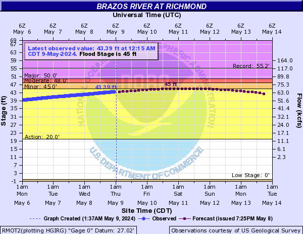
Stage - Brazos River near Richmond, TX
|
|
Streamflow - Brazos River near Rosharon |
Stage - Brazos River near Rosharon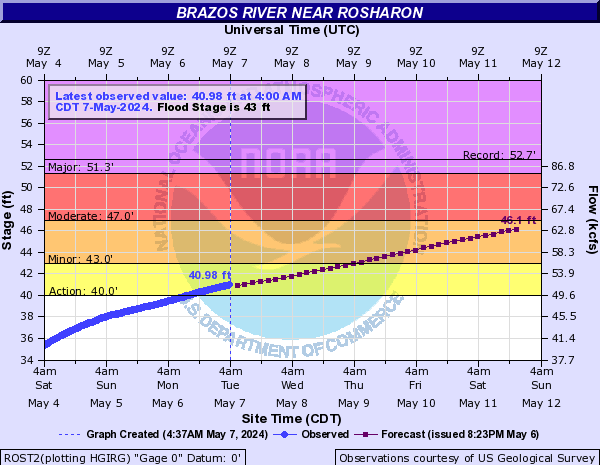
|
|
Streamflow - Brazos River near West Columbia |
Stage- Brazos River near West Columbia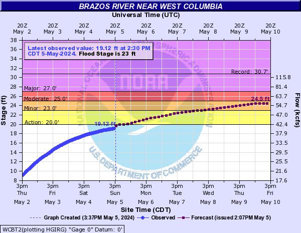
|
Important Links
| Brazos Links |
Brazos River Authority |
USGS Old Brazos River near Freeport |
Brazos River Flood Gates
The Brazos River rises at the confluence of its Salt Fork
and Double Mountain Fork near the eastern boundary of
Stonewall County (at 33°16' N, 100°01' W) and runs 840
miles across Texas to its mouth on the Gulf of Mexico, two
miles south of Freeport in brazoria County (at 28°53' N,
95°23' W). The two forks emerge from the Caprock 150 miles
above the confluence, thus forming a continuous watershed
1,050 miles long, which extends from New Mexico to the
Gulf of Mexico and comprises 44,620 square miles, 42,000
of which are in Texas. It is the longest river in Texas
and the one with the greatest discharge. It has all of the
varied characteristics of a trans-state stream, from the
plains "draw" drainage through canyons at the breaks of
the Llano Estacado, the West Texas rolling plains, and the
Grand Prairie hill region, to its meandering course
through the Coastal Plain. The elevation of the streambed
at the confluence of the two forks is 1,500 feet above sea
level. From this point the Brazos descends to the Gulf at
a rate diminishing from 3½ feet a mile to one-half foot a
mile.
The
Brazos River Flood Gates (BRFG) is situated at the Lower end of the Brazos River on the
Texas Gulf Coast. There are two flood gates-the East and
West gates, both of which have the dimensions stated in
the table below. An average of 50 vessels a day pass
through the Brazos River floodgates. The Brazos River
flood gates provide navigation access through the GIWW,
assisting vessels crossing the intersection of the Brazos
River. The brFG and CRL constitute the western portion of
the GIWW, both of which provide shallow-draft navigation
between deep-draft ports along the Texas coast and
connects these ports to the inland navigation system
comprised of the Mississippi River and its tributaries.
Flooding events within the BRFG area are primarily from
high river flows after heavy rains upstream and/or
hurricanes and tropical storms from the Gulf Coast that
cause severe flooding. During flood and high river flow
events, a hazard exists for all traffic necessitating the
need to provide increased traffic management. In the past,
the industry had self-imposed restrictions by individual
companies, on how and when they transit during high flows,
but that role is now performed by the Lockmaster. The
Lockmaster is charged with operation of the gates on the
Brazos River by issuing gate closures and openings based
on the procedures presented in the “Guidelines for Traffic
Restrictions and Operation of Flood Gates” below. When the
discharges are > 20,000 cfs and river velocities exceed
2.0 mph navigation restrictions are imposed by the
Lockmaster according to the procedures below
USACE Water Management provides information/data support
for implementation and execution of navigation
restrictions for the locks on the GIWW,Galveston District
at the Brazos River crossings. This helps achieve USACE
navigation mission of providing safe, reliable, efficient,
effective,and environmentally sustainable waterborne
transportation systems for movement of commerce, national
security needs, and recreation.
| Length | Width | Maximum Tow Length | Maximum Tow Width |
|---|---|---|---|
| 750 feet | 75 feet | 1180 feet | 55 feet |
The left image below shows the location of the Brazos River flood gates and the Image on the right shows the flood gates on the East and West flanks of the Brazos River as well as the Gulf Intracosatal Water way.
Guidelines for Traffic Restrictions and Operation of Flood Gates
The procedures summarzied in the table below shall be used to guide navigation restrictions for the locks and gates on the Gulf Intracoastal Waterway (GIWW) in the Galveston District at the Brazos River crossings.
When the discharges are > 20,000 cfs and river velocities exceed 2.0 mph navigation restrictions are imposed by the Lockmaster according to the procedures below. Two consecutive velocity readings below 2 mph are required for the river restriction to be lifted.
| Condition | Water Velocity/Height Differential | Restriction Enforced | Restriction Period | Comments/Notes |
|---|---|---|---|---|
| Normal operations | Low flows < 2.0 miles per hour | NONE | NONE |
|
| Restriction Level-1 | Flows are ≥ 2.0 miles per hour or height differential between 0.7 to 1.8 feet | Restrict commercial traffic passage to one loaded or two empty barges | 24-hour day |
|
| Restriction Level 2 | Flows ≥5.0 miles/hour but ≤7.0 miles/hour | Restrict commercial traffic passage to one loaded or one empty barge | During daylight hours but all traffic shall be stopped during night time |
|
| Restriction Level 3 | River Flows ≥7.0 miles/hour | ALL TRAFFIC STOPPED |
- Untill River flows drop below 7.0 miles/hour |
|
| Restriction Level 4 | Height differential is ≥ 1.8 feet | ALL TRAFFIC STOPPED |
- Untill River height differential is < 1.8feet
|
|
Water Management Support
• When high rain/storm events and/or flooding is
forecast, the water management team monitors the Stage
of water at the following gages on the Brazos River:
Brazos River near Rosharon, West Columbia and
Richmond.
• The water management regulator on duty, then
communicate the information on when and where the
river will likely go above flood stage to the
Lockmaster, charged with the immediate control and
management of the gate and of the area set aside as
the flood gate.

