Water Management Data System Menu
Dam Safety Program
Flood risk management is a SHARED RISK and a SHARED
RESPONSIBLITY. USACE and our local, state, and national
PARTNERS are working together to jointly reduce flood
risks, but we must have PUBLIC INPUT to find a
solution.
Reservoirs and detention basins can potentially
eliminate or reduce the effects of flooding. However,
when conditions exceed the design parameters of the
structures, floods become uncontrollable.
• No industry, community or individual is immune to
flooding, hurricanes, rising water level or other events
associated with changing weather patterns.
• As Hurricane Harvey demonstrated, floods are
uncontrollable events that pose great risk to human life
and great cost to property and America's economy and
national security.
• Sound flood risk management programs reduce the risks
to life, property, and critical infrastructure
• Although USACE's understanding of the risk picture has
become clearer, USACE has no reason to believe that the
dam's condition has changed, as a matter of fact, it has
improved due to the new outlet structures at each dam.
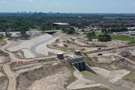
Galveston Dam Safety Program
The U.S. Army Corps of Engineers maintains a rigorous Dam Safety Program that requires continuous inspections of all federally-operated dams nationwide. This program demonstrates our commitment to protecting lives, property, and the environment through continuous assessment, communication, and management. Even though Addicks and Barker Reservoirs are dry much of the time, they are continuously monitored by a full-time staff. The way USACE evaluates dam safety has changed. In the past, we based our risk assessments solely on a dam's structural integrity. Now we use a formula that also considers the potential consequences of dam failure. For example, a dam failure in a large metropolitan area like Houston is more likely to cause major damage, than a dam in a rural area. Based on this new risk-assessment formula, USACE identified two areas of concern at Addicks and Barker that resulted in both dams being designated “extremely high risk.” The structures (or gates) in the dams that open and close to permit outflow into Buffalo Bayou, and The ends of the dams This does not mean that Addicks and Barker are in imminent danger of failing, but the structural issues identified above, combined with the fact that the nation's fourth largest city is located downstream of the dams, resulted in the “high-risk” designation. The “extremely high risk” designation places Addicks and Barker high on the list for funding and expedites all actions related to these two dams.
Frequently Asked Questions: Dam Basics
What is a dam and what does it do?
A dam is an earthen embankment and/or solid concrete
structure that is built across a river, stream, or other
waterway to temporarily hold back (and store water) that
would otherwise flow downstream. USACE constructed and
managed dams are generally quite large, but dams can
also be built on a much smaller scale. Although dams
often provide many benefits, the primary benefit of most
USACE dams is flood risk reduction to downstream
communities. During large storms, the reservoir behind
the dam stores water that would cause downstream
flooding until it can be released downstream more
gradually over time.
• Some reservoirs hold water regularly while others are
dry until a storm occurs upstream. Addicks and Barker
Dams are dry dams.
What are the USACE Dam Safety Program,s primary activities?
USACE uses routine and non-routine activities to inform risk management decisions through the assessment, management, and communication processes. Routine activities include monitoring instruments, conducting inspections, assessing dams for structural and operational integrity, and identifying potential problems and issues. Non-Routine activities include more in-depth risk analyses or studies, an issue evaluation study to determine the extent of a dam safety issue, and identification of temporary actions to reduce the chances or impacts of flooding.
Frequently Asked Questions-USACE Operations
Why does USACE manage these dams?
USACE multi-purpose water resources and infrastructure projects, including dams, are critical to the security, economy, environment, and quality of life for Americans.
As dams in the United States age, their upkeep becomes
even more critical.
• Approximately 95% of USACE dams are more than 30 years
old and more than half are more than 50 years old.
• Population and development around dams can increase,
putting more people and property at risk.
• Typical storm frequency and intensity can change and may
increase the chance of experiencing an event greater than
the dam was designed to manage.
Managing dams on a national scale requires balancing of
competing interests.
• Optimizing competing interests related to a dam or
reservoir requires ensuring that the best interests of the
public are maintained.
What does USACE do to monitor the dam and identify issues? (How does USACE know if something goes wrong?
USACE regularly monitors the dam structure to identify potential issues with the earthen embankment and ensure safety of the structure.
• Dam operations staff conduct weekly walks along the dam
to look for any potential issues or indicators of future
problems.
• Instruments in the dam, read quarterly by operations
staff, monitor groundwater levels, and ensure the dam is
performing as intended.
• These inspections and monitoring increase in frequency
as the reservoir water level rises.
USACE regularly monitors the level of water in the
reservoir at the dam.
• There are gages that measure the water level at
different locations along the dam.
• Information from the gauges is automatically transmitted
to a water control engineer who manages changing reservoir
conditions using computers and modelling in order to
minimize flooding.
• The gages are regularly calibrated to ensure
accuracy.
How often are the dams inspected?
The Corps continually inspects all of its dams nationwide
under its Dam Safety Program:
Dam Safety Program.
The Dam Safety Program based under the U.S. Army
Corps of Engineers Headquarters Dam Safety Program, is
designed to ensure that all federal dams are designed,
constructed, operated and maintained as safely and
effectively as possible. The Corps of Engineers Dam Safety
Program provides a framework to ensure that both short-
and long-term solutions are studied and applied as well as
ensures the protection of life and property. USACE Dam
Inspections are performed annually and the status of the
dam inspections and their conditions are reported in the
National Inventory of Dams at :
National Inventory of Dams.
Do USACE's dams pose risks?
USACE dams, even those that have been designed reduce the risk of flooding downstream, do not eliminate all risk of flooding.
Although unlikely, a significant volume/most of the water
in the reservoir could flow/surge (either controlled or
uncontrolled) out of the reservoir, into the downstream
area and result in damaging flooding.
A significant volume/most of the water could flow/surge
from the reservoir due to:
• the need for dam operators to release high volumes of
water from a dam during normal operations,
• upstream flood waters during rare and extreme weather
events flowing over the top of a dam,
• in a very rare case, a failure of the dam structure.
Most USACE dams have reservoirs/spillways so large that a
significant surge/flow of water downstream could overflow
river channels and result in swift and extremely deep
floodwaters that could be fatal to anyone remaining in the
area when the water arrives.
• Large flows from USACE dams may also overwhelm levees
and/or the storage capacity of any downstream dams.
• Were downstream dams to fail, as with a system of dams,
there would be an additive effect on the total volume of
water flowing downstream.
No matter how well a dam is built, maintained, and operated, unusual extreme severe weather/storms often inconsistent with predicted patterns, could occur that would overwhelm a dam.
How often do dams fail? How likely is a dam to fail?
In general, although dams pose some risk of downstream flooding, dam failures are rare. For example, USACE has had no catastrophic dam failures for the dams it manages in the history of its program.
Dams that are not properly managed, operated and
maintained, and have deteriorated over time, are more
likely to fail than those that are well-managed, and are
repaired or upgraded, as needed.
The likelihood of failure of a particular dam can be estimated only by undertaking an analysis (risk assessment) of the condition of the dam, how well the structure is expected to perform during a variety of flood conditions and the expected impacts of any potential dam failure.
Why do USACE dams exist if they do not eliminate the risk of flooding? What are the benefits of dams?
Without USACE dams built to reduce flood risk, significant flooding would occur more often along the rivers and streams where the dams are located.
By lowering the chance of flooding downstream, USACE dams
reduce the potential for damaging floods and the lost
lives should it flood.Addicks and Barker Dams for instance
have reduced damages of approximately $25 billion.Addicks
and Barker Dams for instance have reduced damages of
approximately $25 billion.
Also, some USACE dams have other purposes and/or provide
additional benefits.
• Other purposes/benefits of USACE dams may include
recreation in and on the reservoir, water quality or
habitat protection along the Bayou, recreation on the
Bayou downstream.
Why isn't USACE fixing the issues that cause the dam risk?
All dams have some level of risk associated with them.
• USACE designs and constructs dams to withstand different
types of expected storms in the watershed to help reduce
destruction associated with flooding.
• However, no dam eliminates all risks; for example, an
unexpectedly large storm could occur that would cause
water levels to exceed reservoir capacity and/or
compromise the dam's integrity.
The consequences of flooding associated with the Addicks
and Barker Dams are high.
• Downstream flooding due to water being released from the
dam during large storms is an infrequent occurrence.
• The chances of flooding due to a problem with the
Addicks and Barker Dams structure is remote as supported
by studies and engineering analyses.
There are relatively cost-effective ways to mitigate the
risks associated with Addicks and Barker Dams.
• The estimate that the dams have “HIGH” risk is primarily
due to the number of people living and working downstream
as well as the massive amount of critical
infrastructure.
• Well-planned and executed evacuations are a relatively
cost-effective way to mitigate the risks of upstream and
downstream flooding to communities, given the extremely
low probability of occurrence.
• USACE's goal is to support local EMAs in the development
of emergency action plans that will reduce the risk to
communities and increase resilience of key infrastructure
upstream and downstream, should the unlikely event occur.
How likely are high volume releases from USACE reservoirs?
Although USACE manages its reservoirs to avoid having to
release water in amounts that will cause downstream
flooding, it does happen on rare occasions.
High-volume releases are a more likely cause of downstream
flooding than failure or water flowing over the top for
USACE dams.
Flooding from high-volume releases is likely to be less
severe than from a dam breach or overflow.
What is the difference between the 'hazard potential' and the 'risk' of a dam ?
“Dam risk” (when used formally) and “dam hazard potential”
are classifications for dams informed by different
criteria with different purposes.
While risk focuses on a variety of underlying factors to inform how much concern should be given to a dam, hazard potential is focused specifically on the potential impacts (such as life loss or economic damages) should the dam fail.
For example, a dam can be considered high hazard potential because people would be in peril should something happen, but still be considered “low risk” because the likelihood of the fatality producing scenario is extremely remote.
What is a Risk Assessment for a Dam ?
The dam risk assessment process identifies key issues that
contribute to a dam's risk and potential actions to
address those issues.
To identify the issues, the assessment considers the flood source and the condition of the dam structure to determine the likelihood that the dam might fail, then estimates the benefits that could be lost if a failure occurred.
USACE has a process to periodically assess the risks of this dam's system and will conduct assessments more often as needed.
What is the 'DSAC' ?
The Dam Safety Action Classification (DSAC) is an
important tool that USACE uses to provide consistency in
risk characterization, communication, and risk management
measures and can be used to help prioritize federal and
local investments.
The DSAC alone does not describe the specific
characteristics of the risk for a dam.
Frequently Asked Questions-National Inventory of Dams (NID)?
What is the National Inventory of Dams (NID)?
The National Inventory of Dams (NID) database/website serves as a central information source/repository for dams in the U.S. and its territories.
The NID includes dams owned and operated by federal agencies, the military, states, territories, tribes, local governments, public utilities, and private entities. It can be found at:National Inventory of Dams.
The database contains information about a dam's location,
purpose, uses and benefits, type, size, last inspection,
and other structural and geographical information.
• There are more than 70 data fields for each dam.
• For USACE dams the NID will also include a summary of
best available risk information.
USACE has been mandated by Congress to maintain NID USACE
to maintain and publish the NID.
What is the purpose of the National Inventory of Dams (NID)?
The purpose of the current NID is to provide public access, including the ability to search for specific data about dams in the U.S.The data in the current NID has also been used to assist federal, state, and local agencies in recommending dam safety policies, including FEMA with their dam safety related grant programs.
The information in the updated NID, including access to maps, will even better help federal agencies, states, industry leaders, infrastructure owners, community leaders, business owners, and residents understand the relationship between dams and the areas they impact.
Who has access to view the information in the National Inventory of Dams (NID)?
The NID is publicly available. Regular users include the
general public, academia, engineering and construction
companies, state and local governments, the federal
government, non-profit organizations, media, congressional
staffers, and insurance companies.
Some dam regulatory agencies may restrict access to
information on dams within their jurisdiction.
Can I (a homeowner) find out in the National Inventory of Dams (NID) and/or from a flood map whether my house will flood? Will a flood map that USACE made for a dam show me my house?
The NID does not address all types of flooding, but does have some, limited information about areas that may flood in relation to a dam failure or operation.
The updated NID will include dam-related flood (inundation) maps that can be accessed by the public, including downstream (and upstream in some cases) residents, business owners, and other potentially affected stakeholders, but only for USACE dams.
The maps in the NID are projected estimates of the area that may flood if an issue with the dam occurs (dam-related flood maps). The estimates are based on best available data but will not include information that is sufficiently precise to guarantee what areas will or will not flood during a dam emergency.
Dam-related flood maps in the NID are not intended or designed to be used for determining individual or personal flood risk but can show the overall potential flood picture within a community and support actions to minimize the impacts of or prepare a community for dam related flooding.
In general, what is included on a flood map for a dam?
Flood maps for dams generally show the estimated areas of potential flooding as represented by a shaded zone that lays over the river or waterway intended to indicate how far water may extend beyond the banks/channel of the waterway.
Flood maps may also include further detail including flood depths, critical infrastructure data and calculations of arrival time (how long it would take for water to reach certain areas downstream).
Most flood maps developed by USACE show possible flooding that could occur in a limited set of scenarios. This information is not typically representative of real-time flooding and is not intended to predict whether flooding will occur.
In general, what is included on a flood map for a dam?
No, flood maps do not explain the likeliness of an event occurring.
Flood maps have been compiled using the best information available; however, the preparation of maps require many assumptions. Actual conditions during a dam emergency may vary from the estimated flooding extents on dam flood maps.Over time historical flood and dam performance information can be used to improve the assumptions made when preparing maps.
How and when will flood (inundation) maps be provided to local emergency management agencies and the public?
USACE includes flood (inundation) maps in emergency action plans (EAPs) it develops for its own dams.
USACE also provides flood (inundation) maps to aid other
federal, state, and local agencies in accomplishing their
missions, especially emergency management authorities
responsible for evacuation planning.
• USACE can provide any flood map data to these entities,
except for data owned by others.
• USACE Districts will notify regional partners and
stakeholders about the availability of flood maps.
Flood (inundation) maps for many USACE dams will be shared
publicly on the updated National Inventory of Dams
database website or through the local USACE district
office.
• USACE shares flood map data with the public. However,
some data is not publicly available such as data owned by
others or supporting data.
• Communities or emergency management agencies who require
more information than the maps that are on the NID's
standard map viewer can use the NID's “advanced map
viewer” feature and/or can work with their local district
to get access to additional information.
USACE is responsible for protecting public safety and welfare by sharing and reviewing flood risk information for USACE-operated or maintained dams with those who need it. But USACE must also protect the security of those dams by safeguarding sensitive information.
Districts can opt out of sharing EAP flood maps with the public for dams where there is significant security concern. There is a process to request that public access to flood mapping data be restricted (excluded from the NID).
What is an Emergency Action Plan (EAP) for a dam and how does it address the dam risk?. What does an EAP include? How does an EAP relate to flood maps?
All USACE operated or maintained dams are required to have
EAPs. EAPs typically include:
• Who should be notified and how they will be notified
during an emergency? • How the emergency will be detected
• What could occur during a dam emergency • Planned
actions to respond during an event • Advance activities
that will be completed to prepare others such as state and
local officials • Advance activities that will be
completed to ensure materials and staff are prepared to
respond to emergencies at the dam.
In situations where a dam failure or a very high release
of water from the reservoir would threaten the lives of
people downstream, the EAP will help to determine who may
be impacted, the downstream critical areas for action and
potential responses.
• During emergencies, USACE uses information in the EAP to
facilitate timely notifications and aid local emergency
management agencies to effectively evacuate potentially
affected areas.
• However, USACE does not have the authority to issue
evacuation orders, so must always work with the state
and/or local emergency management agencies who do have the
authority to issue such orders.
USACE uses information from the EAP to conduct exercises
in partnership with local emergency management agencies to
test planned actions, further improve the EAP, and ensure
all involved know what to do and when during an event.
• This will help EMAs best prepare for their role in
determining when, where and how evacuations should occur.
USACE dams where life safety is at risk
(significant-hazard or high-hazard potential) require
flood inundation maps as part of the emergency action
plan. USACE dams without those risks have the option not
to include flood maps for a dam.
• These planning scenario inundation maps intended to
highlight the downstream and upstream critical areas for
action and are to be disseminated to local EMAs with
EAPs.
USACE shares EAPs and related maps with emergency
management agencies and community leaders and decision
makers in the area downstream of the dam to support
advanced planning and emergency preparedness.
Are EAP flood maps the same as other flood maps? How do EAP maps differ from the other maps USACE produces?
EAP's typically include flood maps modeled on four (or sometimes three depending on applicability) different scenarios two associated with dam failure and two associated with dam operations that result in much higher-than-normal releases of water.
When creating flood maps for EAPs, USACE uses standard
formatting and labeling. This is intended to make them
easier and more accurate for use during USACE and
federal/state/local emergency management functions.
• EAP map standards include graphical design requirements
for: colors, shapes, text format, size requirements, and
required note information, among other criteria. Flood
maps created outside of EAPs do not necessarily adhere to
the same standards.
What are the limitations on the modelling that underlies the map? Why do the inundation areas randomly stop with a hard straight line sometimes?
Limits of the modeling extent may be due to missing ground elevation data or areas of very flat elevation with shallow flooding. In these situations, an abrupt “end” or “edge” to the flood map may be shown.
Sometimes modeling is truncated if the remaining downstream extent would result in no risk to people (i.e., areas of extremely shallow flooding in a coastal marsh area) or in the downstream extent remains in the river channel with no out-of-bank flooding.
Frequently Asked Questions-Public Resources
What can individuals living and working upstream and downstream do to reduce their risk?
Know your Risk:
Contact your local emergency management agency or dam
safety officials to find out more about your local dam,
learn your evacuation route(s), and talk to your friends
and neighbors about the dam.
Know your Role:
Find out how to receive emergency alerts, have an
emergency preparedness plan for you and your family, and
practice it.
Take Action:
Prepare a go-kit, purchase flood insurance, monitor
weather and dam conditions, and evacuate when directed.
